
Material Culture Culture is printed two times a year for members of PAS:APAL. It is abstracted and indexed in: JSTOR, ProQuest, History and Life, Historical Abstracts, GeoAbstracts, and the MLA International Bibliography. You may download a PDF of the table of contents of the current issue here. The Spring 2020 issue of Material Culture includes:
 Antecedent Landscapes and Las Vegas Casinos: Exploring Place through a Referential Perspective
Rex J. Rowley, Department of Geography, Geology, and the Environment, Illinois State University
Abstract The image of Las Vegas known throughout the world differs from the lived experience of Las Vegas residents. Yet, even within everyday, local spaces in Las Vegas, evidence abounds of the influence of the Strip and what it symbolizes. I look to the cultural landscape and suggest the idea of antecedent landscapes as one way to explore a sense of place that simultaneously influences and is influenced by Las Vegas tourist imaginaries. An antecedent landscape is one that serves as inspiration for another landscape. I describe several ways in which place is engendered and evoked under the sway of antecedent landscapes. As a direct reference to the Las Vegas Strip, everyday landscapes — casino and otherwise — illustrate a blurred, complicated, and tethered connection between the tourist’s Las Vegas and that of the local. And, antecedent suburban landscapes that influence these same casino complexes in Las Vegas suburbs illustrate a pattern of casino emplacement within a neighborhood, further underscoring that bond between “Vegas” and everyday life. The idea of antecedent landscapes can be extended to a number of other contexts in order to better understand the human experience in place.
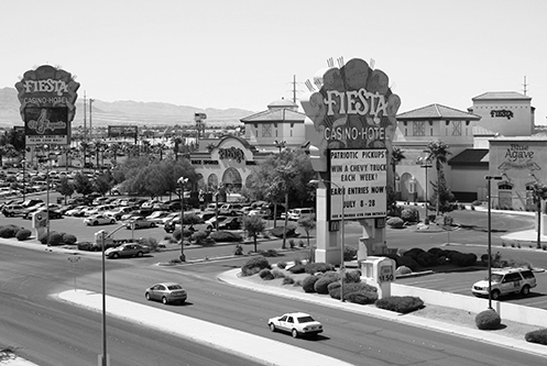
Fiesta Rancho Hotel and Casino. Photo by the author.
“Bowing to the God of Progress:” Automobiles, Urban Planning, & Greenville, South Carolina’s Confederate Monument
Joy Giguere, Department of History and Political Science, Penn State University – York
Abstract: While Southern states made efforts to memorialize the Confederate dead with monuments as soon as the close of the Civil War in 1865, the 1890s through the first decades of the 20th century marked the zenith of these activities. It was during this time period that monuments were placed in public spaces such as street intersections and courthouse lawns rather than in cemeteries. What many monument committees and communities failed to anticipate was how technology — particularly the popularity of the automobile — and urban expansion would force residents to reckon with the monuments erected during an earlier age. In the culturally charged atmosphere of the 21st century, in which the issue of Confederate monument removal is at the center of heated debates over questions of propriety vs. preservation of historical objects, an understanding of these objects as being subject to removal and relocation over the course of their history has largely been lost. The decision by city officials to relocate the Confederate Monument in downtown Greenville, South Carolina in the 1920s sparked a landmark series of court cases that ultimately resulted in the State supreme court ruling in favor of the city and its removal to the town’s Springwood Cemetery. This case established the precedent for the removability of monuments and paved the way for dozens of subsequent removals and relocations over the next half century.
Historical GIS for Vernacular Architecture Surveys & Virtual Reconstruction of Urban Cultural Landscapes: A Case Study in 1850s Wheeling, (West) Virginia
Dan Bonenberger, Department of Geography and Geology, Eastern Michigan University
Abstract: The reconstruction and interpretation of early American streetscapes is a tremendous challenge for preservationists and Virtual Heritage scholars alike. In historic preservation, reconstruction is taboo due to concerns over uncertainty and authenticity. Wheeling (West) Virginia’s Webster (now 20th) street, for example, has been so drastically altered by urban development and redevelopment over the past 160 years that only a single building from the 1850s survives. Lack of knowledge about this place has hampered the ability of scholars to interpret the early influences and world view of Rebecca Harding Davis, who lived there during the years prior to writing her seminal works of American Literary Realism. This paper examines opportunities and challenges associated with a geographic approach to the virtual reconstruction of such places. The methodology includes several important steps beginning with the identification, digitization, and storage of archival evidence. Historic maps were georegistered to recent orthophotographs in a Geographic Information System (GIS). Subsequent analysis identified likely surviving contemporary dwellings nearby, which were verified by research in deed and tax records and intensive field recording. To reconstruct the cultural landscape of Webster street, where Rebecca Harding Davis lived in the 1850s, 3D digital models were produced in SketchUp to visually reflect the quality of data available for each building. Accurate models of vernacular architecture and other cultural landscape elements were assembled upon a digital terrain model in Unity3D, and the scene was exported into the HTC Vive head-mounted Virtual Reality display. The entire system is evaluated as a tool for historic preservation, cultural geography, education, and interpretation.